go to WASHINGTON FREE PRESS HOME (subscribe, contacts, archives, latest, etc.)
March/April 2000 issue (#44)
When the Space Needle rose over Seattle the central Puget Sound panorama visible from the 1962 World's Fair icon was home to a little over 1.5 million people. By 1998, only 36 years later, population had doubled to 3.1 million.
Today a forest of skyscrapers has grown as high or higher than the Needle, while the green forested band that hugged closely around Seattle proper in 1962 has thinned and been displaced outwards. Sprawling human settlement covers vast new tracts of former forest and farmland. From 1970-95 while central Puget Sound population grew around 50 percent, land covered by houses and businesses grew 100 percent, doubling to over 200,000 acres.
But current low-density, automobile-centered sprawl is not the inevitable outcome of market forces. In reality it is the outcome of arrangements that understate costs by shunting them onto the general public and the environment. These costs fall into five general areas: longer drives and wasted time in traffic, tax burdens to build new sideurban infrastructure, air pollution that causes illness, lost mountain visibility and climate disruption, and watershed damage which intensifies flood and drought extremes and endangers salmon runs.
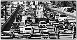
17,000 years stuck in traffic
"Not surprisingly, as residential densities go down, the proportion of trips made by auto, the length of trips and the total number of trips all go up," the Puget Sound Regional Council (PSRC) notes.
From 1960-90 the average Puget Sound driver increased daily driving from 9.3 miles to 22.2 (about where it has remained since). From 1960-96 the average Sound commuter increased their one-way trip from 7.4 miles to 10.6. "The growth in distance especially depicts the pattern of sprawl, with many people choosing to live in sideurbs and rural areas, far from their places of employment," PSRC concludes.
In 1960, Puget Sound commuters spent on average of 22.6 minutes traveling to work one way. By 1996, commutes had grown 25 percent to 28.5 minutes. The added commuting time is one hour per week, like tacking an extra 50-hour workweek to the year.
Another measure is time lost to congestion during trips for all purposes. By 1995 Puget Sound people annually spent 78 million hours stopped in traffic on freeways and arterials. That amounts to 36 hours stuck in congestion for each driver. Under current trends, by 2010 time lost to traffic nearly doubles to 150 million hours -- 56 hours for each of the 2.6 million drivers then using regional roadways. Translating those hours into years, Puget Sounders sacrificed 8,904 human-years to traffic in 1995. Just 10 years from now the annual human-year toll mounts to 17,123.
Draining the taxpayer
New sideurban houses create additional demand for schools, roads, sewers, stormwater drainage, water service, roads, parks, fire stations, libraries, etc.. Their total cost amounts to $20,000 to $30,000 or more for a typical new single-family house in the sideurbs.
The Carnegie Group, a Thurston County citizens' organization, found that from 1997-2002, county residents will pay $449 million for infrastructure to accommodate growth. $358 million will be charged directly to local taxpayers, about $600 per taxpayer each year. Only 14 percent will be covered by developer fees and other non-local taxpayer sources. Local sewer plant expansion to handle growth adds another $385 per taxpayer. Tagging on costs of operating all the new facilities could bring the total yearly growth bill to $1,200 per taxpayer.
Schools are the most expensive public facility required by residential development. The Issaquah School District has calculated school construction costs of $18,600 for each new single-family house. Deducting impact fees and a small contribution from state taxpayers, a minimum of $12,000 is carried by all local taxpayers.
Extending the road system is typically the second largest fiscal cost of sprawl. Snohomish County recently examined whether to retain the current Lake Stevens Urban Growth Area or adopt a smaller, more-compact one. Adding 4,013 urban acres, rather than the 5,804 under the larger alternative, would save about $39 million, or 14 percent, on total road costs.
Public expenditures on roads are not keeping pace with growing traffic. Puget Sound transportation needs for 1996-2020 are $66 billion. But guaranteed revenues available for transportation are only $37 billion. Before I-695 deeply cut state license tab revenues, another $15 billion had been expected, but now a portion of this funding is uncertain.
"You could draw the conclusion that new growth is not paying its way," says PSRC Metropolitan Transportation Program Manager Ralph Cipriani. "We know it's more expensive to provide services to sprawling development."
Puget Sound car and truck air pollution costs $267 million annually. The conservative PSRC estimate was based on a cost of one cent per noncommercial vehicle mile, two cents per commercial mile. A U.S. Office of Technology Assessment report which includes costs PSRC did not, such as global warming, indicates costs as high as 10 cents per mile.
Vehicles are the top source of hazardous air pollution in Puget Sound. Gains in clean car technology have been swamped by a 40 percent growth in the vehicle fleet from 1980-96 to 2.5 million. This is driving the region out of compliance with federal clean air rules that cap lung-searing, ground-level ozone, threatening the region with costly new restrictions on business, drivers, even lawn mowing. Children are an even greater concern, their hospitalization for asthma leaping 34 percent in the region since the late 1980s, to 470 per 100,000 children. At least part of the rise is due to ozone.
The greatest potential air pollution cost may be destabilization of the climate. Transportation is the largest and fastest growing source of Washington State carbon dioxide emissions. Emissions from gasoline and diesel powered vehicles rose from 10 million tons in 1960 to 30 million tons in 1995. Puget Sound cars and trucks were responsible for around half the state total. A range from $10-$40 per ton of CO2 emissions is commonly cited as the cost to mitigate greenhouse emissions Using that range, Puget Sound surface transportation in 1995 had a greenhouse cost of $160-$640 million.
Air pollution also diminishes mountain visibility. The sight of Rainier, the Cascades and the Olympics on a sunny day provides Sound residents with virtually unquantifiable aesthetic value. But measured by days the mountains are visible, increased air pollution has robbed the region of around one-third that value since the late 1980s.
Across Washington and Puget Sound, streams that once gave birth to abundant salmon runs now witness sharp declines. In the greater Puget Sound region 23 percent of salmon stocks are rated critical or depressed. Recent Endangered Species Act listings of salmon blanket Seattle-Tacoma and Portland-Vancouver, the first large U.S. metro areas to come under the ESA.
Recovery costs are bound to be huge. Derek Booth of the University of Washington Center for Urban Water Resources estimates that restoring streamside habitat and relying on hatchery salmon would cost roughly $1 billion throughout the urbanized Puget Sound.. Restoring fully self-sustaining runs, even if possible, would likely cost "at least an order of magnitude" beyond that. An unofficial Department of Community, Trade and Economic Development assessment of statewide local government expenditures on salmon recovery over the next 10 years sets a figure of $2 billion.
Even with large expenditures, Booth says, "It's not clear that the limiting factor in an urban setting is money. There's a knowledge gap as well as a money gap. The science of salmon living in disturbed watersheds is pretty young."
When humans begin to extend the urban footprint into a rural watershed, the greatest change is nearly always a radical acceleration of storm runoff. Water that might once have gracefully seeped through forest soils to streams over months now slushes off pavement in hours. Two to five times more water rolls off during peak rainfall runoffs. Flow magnitudes generally run five to 10 times longer. Flows powerful enough to carry sediment and disturb habitat come 10 times more frequently.
Hydrological engineer Thomas Holz compares the effect to a fire hose. Surging waters dig stream channels deeper and wider, sluicing away pools and other salmon habitat. Since water flows out instead of recharging groundwater, it is no longer available to fill those larger channels during the summer dry spell. For salmon one year of dry streambed is not a statistical blip but an extinction threat.
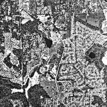
| Aerial photos of the East Sammamish area of Bellevue in 1970 (top) and in 1995 (bottom). |
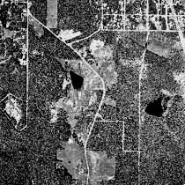
|
|
Shocking many experts is new research showing that even in the first stages of urban development, salmon runs and overall stream health can catastrophically plummet. Many studies have shown that once more than 10 percent of a stream's watershed is covered with paving and building, the biological health of streams begins to seriously decline. Ten percent is the equivalent of one single-family home per acre. But recent biological inventories of Puget Sound streams are finding that stream health can catastrophically collapse even after the first 3-8 percent. The first cut into a watershed can be the deepest.
It is time to invent a new American dream that moves us to the kind of healthy, vibrant, safe neighborhoods most people want, without the costs and aggravations sprawl is so clearly bringing. Here are five ways:
1) Move to Redevelopment -- Infill and reuse existing urban land, emphasizing pedestrian-friendly design, links to transit, and safe and convenient access to shops, services, and open space.
2) Make Costs Transparent -- Local governments should provide Community Impact Statements detailing the impacts of major developments and land use decisions.
3) Use Taxes And Fees to Encourage Efficient Development -- Dramatically revise impact fees to capture as much of the public costs of development as possible. Make fees variable to reflect cost differences between serving sprawl and compact development. Consider eliminating property taxes on buildings altogether, taxing land exclusively to discourage speculation and encourage infill.
4) Price Road Use -- Implement a vehicle-miles-traveled fee. While politically challenging, its ability to reduce congestion will become an increasingly strong selling point as highways move toward gridlock.
5) Revisit Urban Growth Boundaries -- Where watersheds have healthy salmon streams and little development so far, it will likely be far less costly to restrain development and save the best, than to try to fix the damage.
We can bring sprawl to a crawl if we focus development on existing cities and sideurbs and develop in a more compact manner. Ultimately the costs will be far less, while the payoff will be a new American dream of truly good places--good for air and water, good for children and salmon, good and satisfying communities for all of us to live in.
This article is based on a new report from Climate Solutions and the Sierra Club, Taking Its Toll: The Hidden Costs of Sprawl in Washington State. The report is available at www.climatesolutions.org, or by calling 360-352-1763 or writing info@climatesolutions.org. Patrick Mazza is staff writer-researcher for Climate Solutions. Eben Fodor is a Eugene, Oregon-based public interest community planning consultant and author of Better Not Bigger: How to Take Control of Urban Growth and Improve Your Community, New Society Publishers, 1999.
|
go to WASHINGTON FREE PRESS HOME |